


New website highlights key role of Geographic Information Systems |22 November 2013
People wishing to access details of land plots in a particular area or visitors planning a holiday here and want to know more on different tourism related establishments can now do so via a newly launched website.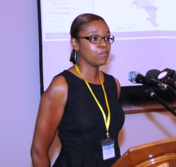
The Geographic Information Systems (GIS) website called WebGIS is located on the Ministry of Land Use and Housing website at: www.luh.gov.sc
It was launched yesterday morning during activities organised at the Centre for GIS and the Planning Authority on the ground floor of Independence House to mark International GIS Day which fell on November 20.
The principal secretary for Land Use and Housing, Joseph François, launched the website in the presence of the Minister for Land use and Housing Christian Lionnet as well as other key officials from the same ministry and the Planning Authority.
Cynthia Adrienne, senior GIS officer and her colleague Dave Roseline provided a detailed explanation on the functionality of the new WebGIS system.
She explained the different features that have been included on the programme.
Other than the launch of the website, the activities yesterday also included an exhibition in the lobby of the Independence House where staff of the Centre for GIS explained the countless benefits of using the WebGIS to members of the public.
Addressing all those present to witness the launch Mr François stressed the importance of the uses of Geographic Information Systems in our everyday life even when the majority of us are not realising it.
“If you are one person thinking that you do not use GIS, and that you do not need it, please think again because you certainly do use GIS, and not only use it but you can no longer live without it,” said Mr François.
He pointed out that without thinking, GIS has risen in our everyday life, has entered our workplace and businesses, our house – from GPS devices for fishermen, drivers, and navigators – through Google Earth for students and internet users, and geo-tagging.
“Your many smart phone applications, social media tools combine data with maps, so many people in Seychelles are using GIS technology every day without realising it,” he added.
He noted that even before the average computer user was using GIS on a near daily basis, everyone has benefited from it. The government has used GIS to decide on electoral boundaries for districts, to analyse population distributions and dynamics, and even down to street lights, water pipe networks and electricity distribution network.
“The real power of GIS is that it is more than a map; it is a map that can show us exactly what we want to see,” said Mr François.

