


Multi-species acoustic tracking project underway at Bay Ternay |30 April 2012

The Seychelles Fishery Authority (SFA) and the Seychelles National Parks Authority (SNPA) are working cooperatively with MCSS to help this project succeed.
So far several sharks, groupers, turtles and stingrays have been fitted with acoustic tags. These tags give off acoustic signals and are either placed surgically inside the animal (in the case of sharks and groupers) or on the outside of the animal (stingrays and turtles).
The signals from the tags are picked up by receiver stations that have been placed in a grid pattern on the sea floor inside the bay and in lines between Bay Ternay, Conception and Thérèse.
This allows us to track the movements of tagged animals inside the marine park as well as those travelling in and out of it through the Conception channel. To collect the information from the stations, divers have to dive down to pick them up and download the detections onto a computer. This information can then be mapped using Geographical Information Software (GIS).
At this stage, the receivers downloaded from the Bay Ternay array have yielded several thousand detections from the tagged animals – that means a lot of data to analyse! Preliminary analyses have shown that different species and different individuals of the same species, seem to have their own core areas of the marine park where they spend the majority of their time.
The amount of time that an animal spends in the vicinity of each receiver can be displayed on the digital maps. These can also be put on top of a map layer that shows the habitat types found within the bay (kindly made accessible by Jude Bijoux of the SFA and Justin Prosper of the GIS Unit of the Environment Department).
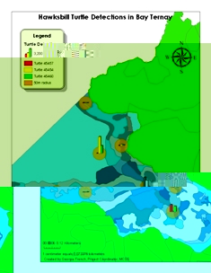
This then shows us which habitats our tagged animals like to spend their time in, which can be further split into day and night to see where they like to forage and sleep and day/week/month to see if there are temporal factors that affect how the animals are distributed. The map provided shows the areas that our critically endangered hawksbill turtles like to use by showing the number of detections of each turtle on each receiver that they have been picked up on.
None of this work would have been possible without the help of local fishermen and volunteers who have helped us to locate and catch our target species. Artisanal knowledge of where and when to find different species has proven to be very useful for the success of this project. In turn, all those taking part are provided with information on the species, with a focus on why they need protection and how individuals can help. Presentations have also been given to school children to educate them on the project goals.
