


The Anse à la Mouche coastal transition |10 August 2013
 |
 |
 |
 |
 |
 |
 |
 |
The Anse à la Mouche coastal zone is situated in the south west of Mahé and is located between two headlands. Such strategic location implies refraction of waves is consistent in the area. Being placed between two headlands also implies that the main mechanism of sand transport is onshore and offshore as opposed to longshore sediment transport for linear/straight beach.
Assumed causes of erosion in the area relates to the low lying characteristic of the Anse à la Mouche plateau coupled with increased frequency and intensity of storm surges which leads to net loss in sand as offshore transport of sediment exceeds onshore transport in such cases and the sand that is lost is not returned.
Moreover it has been shown that existing man-made feature (being the stormwater outlet) which acts as a groyne has contributed to loss of sand on the downdrift side of the structure.
The cumulative effect of erosion over the years along the beach was intensified in 2011 following the Bondo cyclone that caused extreme scouring in some specific places up to the road, threatening its condition by undermining. The erosion had also overtime led to the loss of not only huge amount of sand and land but the vast number of trees that buffered this area, creating a threat to the road network and the properties overlooking the beach front due to wave surge. In response to such extreme impacts, the Coastal Adaptation and Management Section (CAMS) of the Environment Department mandated for coastal conservation and protection works intervened through planning for a coastal protection and rehabilitation scheme for the area.
The President of the Republic himself, James Michel, facilitated and strongly supported the intervention following his visit to the area with officials of the Environment Department in 2011.
Director for the section, Nimhan Senaratne, detailed the proposed methodology and design layouts to the delegation and as result was able to secure much needed funding for a prior unfunded coastal unit resulting in the momentum of this project and other coastal protection schemes implemented either solely by the section or in close collaboration with NGOs and international funding grants.
The local inhabitants were also major actors given their voicing out of the status of the area and their continuous support and acknowledgment of the whole process of the project from simple complaints of the erosion to direct on site involvement in the rehabilitation project such as donating rocks for blocking off vehicles from parking.
The Anse à la Mouche beach front is among the most frequented beaches of the island and is well reputed for its calm waters and lovely scenery.
However with increased erosion, part of this stretch of beach (opposite Blue Lagoon and Anchor Café) has lost some visitors.
Considering not only the factor of protection and recreation of the beach but also public, the CAMS designed the rehabilitation project to meet both natural and public needs.
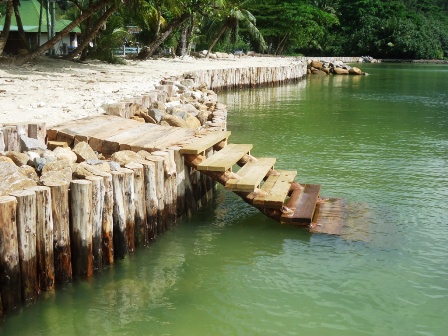
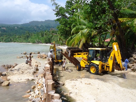
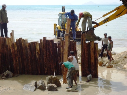
The first phase of the project focused entirely on reinstatement of the area by the use of mixed soft and hard engineering techniques. This included reclaiming an approximate 18 meters wide of the lost beach for 178 metres using coral fill to recreate the dune and armoring this land with a matrix of timber pilling structure for the entire length. The piling work being a soft structure in nature should allow for deposition of sand as waves surge through and are trapped behind the pilings cloth with geo-textile fabric.
Two small groynes have also been placed strategically to allow for sand deposition in front of the timber pilling so that accumulation works on either sides of the piling structure.
This was planned also to allow for another featuristic mountain headland component during the landscaping part of the project. Casuarinas as a coastal plant are considered to be the most ideal timber for coastal piling given its adaptability to salty conditions hence longer life span compared to other plants.
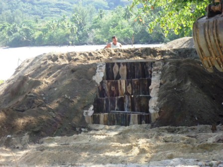
However it was very difficult at that time to allocate an area for acquisition of the timber. Given Romainville island was to be cleared off to commence the installation of the present wind turbines, it was identified as the ideal location to extract casuarina logs for timber. The project required 2000 numbers of 3m length of casuarinas to be placed along the 178m along the coastline purposely to act as a defense barrier from incoming waves, armor the reclaimed dune and trap sand.
The project also required more than 2000 tonnes of coral fill and 1500 tonnes of rocks to backfill the area which was extracted at Providence and Perseverance Island.
In total for only cutting, loading, transporting and dumping these materials cost a sum of more than R1 million.
It took about seven months for Ascent Construction, the company that secured the contract through formal tendering, to complete the project for the sum of R2.1 million in total.
Upon completion of the first phase which allowed for reinstatement and stabilisation of the land, the second phase of the project was designed and retendered separately.
Phase 2 started early 2013, purely for the purpose of rehabilitating the area. It is focused on ground preparatory works for eventual replanting. The newly landscaped beachfront will serve the community by allowing low key activities to be undertaken on the reclaimed and rehabilitated area. This phase is currently under implementation by Terrence Lafortune, the director of Sun’s Excavation Company Ltd and is near completion.
Phase two of this project is expected to cost a sum of more than R300,000.
The requirements for the implementation of this phase was 200 tonnes of alluvial soil which was mostly acquired from river desilting in eastern side of Mahé during the three days of heavy rainfall in January, 90 tonnes of macadam and coral fill, 30 tonnes of rock boulders.
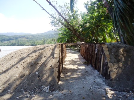
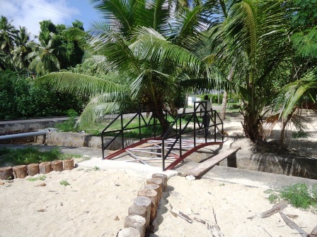
There are several features which have been incorporated or will be placed at the site as part of the landscaping design for recreational purposes as example an observation hill, a reflection walkway, rock gardens, a scorpion shaped wishing well and a hump bridge. All of these features have been inserted with a vision in mind of different ways that will serve the community.
For instance the hump bridge will serve the road users by diverting the pedestrian through the landscaping area since there are no pavement present, and will reduce risk of accident.
The earth bunding all along the road is to limit vehicle from accessing the coastal front and parking on the rehabilitated area. However to cater for vehicles there will be a cleared space at the other side of the stormwater channel that will serve public parking. This will allow families who want to access the area to park their vehicles and prevent traffic congestion along that line of the coastline from dense parking. This is purely to prevent trampling and destruction of coastal vegetation.
The reflected corridor will have a special part where pictures will be carved inside the wooden pile, where visitors can stop and take a journey back into ‘memory lane’ understanding the merit of the project given before situation.
Wooden steps are also placed from timber piling edge (as a safety measure) into the water to serve people who want to get access to the water (given the current height of the pilings). The observation hill will give a proper view of the sunset and the wooden strip will demarcate public pathway.
After completion of phase two, the site will be handed over to the Landscape and Waste Management Agency which will be in charge of revegetating the area. This will form part of phase three which is the final phase of the project. With the creativity and green touch of the chief executive LenaDesaubin, it is expected that the coastal protection shall be enhanced to a coastal park entailing walkway, benches, bins and other aesthetically pleasing yet low key physical structure appropriate for a coastal front.
To start this phase it will require 350 tonnes of alluvial soil for landscaping. The entire area will be planted with different types of coastal vegetation to stabilise these sediments that will be included in the reflection corridor, the observation hills and the earth bunds.
The rock garden will have vacoa planted into all three of them characterising the essence of family. The rocks will also be flattened to allow for seating. There will be several patatran gardens which will be planted inside the wooden pile found close to the sea whereas coconut trees will be scattered along the site away from the piles given its fibrous roots threaten the piling base.
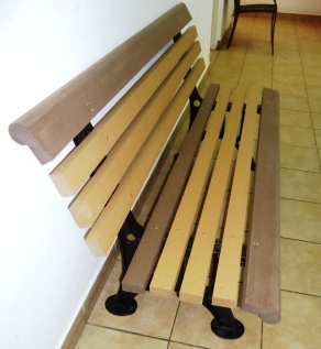
After completion, litter bins will be placed in strategic locations as well as benches to accommodate visitors from which time the general public may make use of the area.
In general the Coastal Adaptation and Management section believes that the project has been successful so far. Although it was difficult especially at the begin for the acquisition and purchasing of the materials, tidal movement causing delay to work progress, providing less working hours and other issues such as facing another storm surge during implementation, CAMS acknowledges the effort of the different stakeholders especially the contractors giving their best, the public in general and the ministers and president himself who remained involved during the length of the project implementation.
As well as the dedicated staff of the CAMS devoted to the project and other stakeholders such as the school of agriculture and horticulture training center for their technical contribution from beginning of project, LWMA for technical advice and willingness to take up maintenance of the area in collaboration with CAMS.
A special mention of course goes to the neighbouring property owners who have influenced the project with information of the past status of the area and their continued sense of belonging to the project in all making the project a success to the point of being showcased an international arena as an exemplary case of coastal adaptation efforts to climate change.
It should also be noted that on a community level this project could be set as an example whereby the community and the government has worked together to achieve part objective of the Integrated Coastal Management. It is strongly hoped that upon completion of the project the public acknowledges the effort, expenses, commitment and general purpose of this project hence enjoying this part of the coastal area wisely respecting the natural protection of the place.
Contributed